Monday 19th July 2021
Well we were up early today as we still have 7.5km to hike before our collection at George Point at midday. So after packing up we had one last swim in the Mulligan Falls rock pool. It felt a lot cooler this morning and the sun was hiding behind the clouds today.
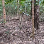
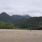
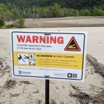
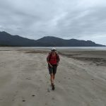
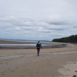
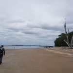
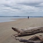
We set off at about 9am with an expected 2.5 hour hike to go. We started through the vibrant green rainforest, crossed some creeks, walked through swamp land, passed areas ravaged by wild boar, up and down a few steep rocky hills, passed some amazing trees, then we made it to the beach. We were lucky it was overcast as it was still a long walk along the beach and in bright tropical sunlight it would have been very hot and uncomfortable. It was very low tide but once again I stayed a long way from the water, I was a big chicken, David couldn’t convince me to get closer. We came to the big crocodile creek but as it was planned the crossing was at low tide so we didn’t even have to remove our shoes. There had been a crocodile sighting there within the last seven days, but unfortunately for David it wasn’t to be seen today. Some times the crossing is waist to chest deep, with crocs about that is definitely not for me. The beach was strewn with trees washed up on shore.
The entire walk was quite spectacular, the terrain and scenery so diverse, the waterfalls and swimming holes so refreshing and beautiful and clear, it was an exceptionally amazing hike. One we would recommend to anyone interested in remote multi-day hikes.
We waited for about 30 mins for John to arrive to ferry us back to Lucinda. We then enjoyed a lovely lunch at the Lucinda Point Hotel with our new friends from the hike.
After lunch and on the way to Cardwell, John had given David the GPS co-ordinates for a 4m crocodile sighted today at Hallifax but unfortunately it was no longer there. Poor David was so disappointed. We then headed on to Cardwell, a 45 minute drive north to our home for the next two nights, a comfy bed and a shower. Yay!!
Day 4 – Track Notes
Mulligan Falls to George Point (Grade: difficult)
Distance: 7.5 km Time: allow about 2.5 hrs hiking time
Use caution when crossing Diamantina Creek, particularly if the creek is swollen after heavy rain. Follow the markers diagonally across the creek before the trail continues up a short slope and descends a steep hillside to reach the base of Mulligan Falls. Camping here is restricted to one night. The vegetation in this area is typical of lowland rainforest communities found on Hinchinbrook Island. On a clear day, this section affords good views of Lucinda and the Palm Island Group. Do not enter the restricted access area at the falls. Death and serious injuries have occurred when people have entered this area. Rock pavements, including those well back from the falls, are extremely slippery and dangerous. Collect fresh water before leaving Mulligan Falls as water sources are not reliable further along the trail.
Mulligan Falls to George Point (Grade: difficult)
Distance: 7.5 km Time: allow about 2.5 hrs hiking time
From Mulligan Falls the trail follows the coast, travelling through rainforest and crossing five creeks. The last, Moth Creek, provides only seasonal fresh water and should not be relied upon. About 300m south of the Diamantina Creek inlet, a sign indicates the northern entrance to Mulligan Bay. George Point the southern exit of the trail, is a further 5 km walk along the beach. About 2 km along, Mulligan Creek flows into the bay and it is advisable to cross this creek at low to half tide. Fresh water is not available here or at George Point, at the southern end of Mulligan Bay.
-
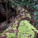
- Some amazing fallen trees near our camp at Mulligan Falls..
-
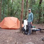
- ..our tent setup in the Mulligan Falls campground..
-
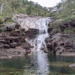
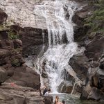
- ..a quick swim in the pool at Mulligan Falls..
-
- ..a bit of a chat to the girls before heading on our last day of hiking.
-
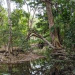
- Yet again, amazing trees line the track..
-
- ..some with the most amazing root systems..
-
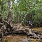
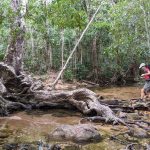
- ..which we utilise to get across the creeks..
-
- ..they are amazing.
-
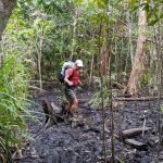
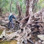
- Other times we use fallen logs to avoid sinking in the muddy swamp..
-
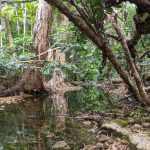
- ..the beautiful clear water creek crossing..s..
-
- ..are plentiful as we continue along the trail..
-

- ..passing revegetation areas fenced to keep out the wild pigs..
-
- ..as they ravage the forest floor and leave it in such disrepair.
-
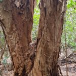
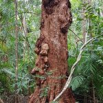
- Once again another amazing tree..
-
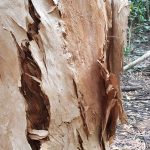
- ..with a closeup of the bark..
-
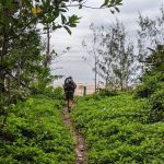
- We finally emerge onto the beach for the final stretch..
-
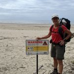
- ..along the sand, with yet another croc warning..
-
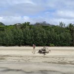
- ..as we continue south to George Point..
-
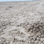
- ..we see many sand crab balls..
-
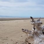
- ..a lot of dead trees have been washed ashore here as well..
-

- We reach the creek crossing which being low tide we were able to keep our feet almost completely dry..
-
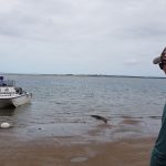
- David going up closer to the creek mouth hoping to see a crocodile whilst I waited back on the beach..
-
- ..as there had been a re in the last seven days. Unfortunately NO CROCS to be seen..cent sighting
-

- ..but we did see a star fish in the sand..
-
- ..as we continue walking the last 2km..
-
- ..to George Pt..
-

- ..we see some lovely shells along the way..
-
- ..the final corner and you can see the long jetty for the sugar to be loaded on the ships in the distance.
-
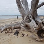
- Look at the root system in this tree..
-
- ..and some more drift wood as we round the ceoge Point.orner to G
-
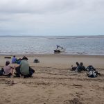
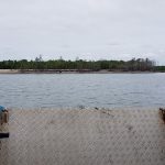
- Sitting at George Point waiting for the second boat to arrive…
-
- Almost time to leave this amazing island..
-
- ..On the boat now as we head back to the mainland.
-
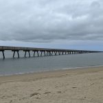
- Lucinda Jetty – At 5.76 kilometres long, supported by more than 660 concrete and steel pylons, the jetty is nothing short of an engineering masterpiece with its length actually following the curved contour of the earth. Sugar takes 22 minutes to travel along the conveyor from the on-shore storage to the shiploader. The single berth can accommodate fully loaded Panamax class vessels and the major cargo destinations are Canada and Malaysia.
-
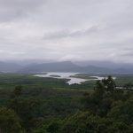
- On the way to our new home at Cardwell tonight we stopped at Panjoo Lookout where we could see Hinchinbrook Island across the channel.
-

- At last, a room and a comfy bed for the next 3 days..
-
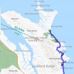
- We travelled by boat from Lucinda up the channel between the mainland on the west coast of Hinchinbrook Island following the dashed line around the headland and down one of the outlets to the green dot. This was the start of the 32km hike. Day 1 Ramsay Bay to Little Ramsay Bay 6.5km. Day 2 to Zoe Bay 10.5km. Day 3 to Mulligan Falls 7.5km. Day 4 to George Pt 7.5km. Then the boat from George Pt to Lucinda. What an amazing adventure. Woohoo!! Bucket list item. Check. Woohoo!!