Sunday 18th July 2021
We had a bit of a rough night with nightlife around our tent, either a marsupial or rats. They just kept ratting around the tent, rustling on the leaves but at least they didn’t chew through and get in our tent. I got up and did some yoga as the sun rose. It was truly beautiful. After lots of chatting with our fellow camp mates we set off about 9 am. First was a quick stop at the bottom of Zoe Falls, then up the steep rocks, a rope climb up a sheer rock face, a lot harder with 13kg on your back but the practise last night made it a lot easier. The granite rocky slabs at the top of the falls are magnificent. We had a swim at the top of the falls before we set out for today’s 7.5km hike. Estimated time is about 4hrs. After filtering our water and our swim we were on our way again about 10.30.
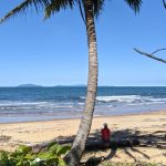
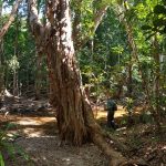
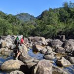
Once again today was varied, there were steep forested slopes which were quite tough again, many creek crossings, beautiful grass tree shrubs and amazing views out to the ocean. At about 1pm we took the side track down to Sunken Reef Bay. This was down a steep rocky descent of 100m elevation to sea level. It was a tough gig, with a wide creek crossing along fallen tree trunks. It felt a bit crocodiley too. Anyway we made it to the beach but it was a bit disappointing as it was quite littered with plastics washed up on the shore. We enjoyed some lunch in the peacefulness then headed back across the creek and up the 100m rocky track. Oh well. It was only about another 40 mins to camp. We made in to camp about 3.10pm, set up our tent and headed to Mulligan Falls for a well earned swim. These falls were also spectacular but as they were in the shade they were a little cool but very refreshing after our long day.
As is always the case it takes the camp group a couple of days to get comfy, but we enjoyed a nice evening sitting around chatting with our new camp friends. The father and daughter were Tash 29 and Steve who just retired from Brisbane, Alice 27 and Keela 25 from Cairns, Jim 69 from Port Stephens who had done the whole hike in barefeet and thongs, and Sean from Melbourne (originally from Ireland). We all shared some of our travel stories, life stories, and all in all it was a great night. There was also a dad with his 10 year old daughter, another family of 4 parents called Sabina and Ryan with 10 and 15 year old daughters. They were doing amazing. Well we only have one day to go. It has been a great challenge physically but with spectacular rewards. Another great experience.
Day 3 – Track Notes
Zoe Bay to Diamantina Creek (Grade: difficult)
Distance: 6.5 km Time: allow about 4 hrs hiking time
From the Zoe Bay camping area, the trail runs parallel with South Zoe Creek, crossing it about 100 m downstream from Zoe Falls. It then continues up a steep slope onto the granite slabs above the falls where there are spectacular views of Zoe Bay. Please remain on the trail at all times and do not camp at Zoe Falls. Continuing along South Zoe Creek, the trail occasionally crosses narrow rocky tributaries. It then follows a distinct spur to the granite rock pavement of a saddle. At 260 m above the sea, this is the highest point on the trail. On a clear day the picturesque views include the Palm Island Group and Magnetic Island to the south. Tall heath communities, typical of much of the mountainous parts of Hinchinbrook Island, dominate this section of the trail. After crossing the saddle, the trail traverses steep forested slopes of the Sweetwater Creek catchment before climbing into coast sheoak and grasstree shrubland. The trail then descends into the Diamantina Creek catchment, passing a sidetrack to Sunken Reef Bay, before reaching the Diamantina Creek crossing.
Sunken Reef Bay
Thirty minutes walk along a sidetrack takes you to Sunken Reef Bay camping area. Water is available from a small creek at the northern end of the beach. During the dry season, water can be obtained from Diamantina Creek. Camping behind the foredune is popular with sea kayakers and hikers. Between October and March be aware that beach stone curlews) and the occasional green turtle nest here. Remember, camp fires are not permitted.
Diamantina Creek to Mulligan Falls camp (Grade: difficult)
Distance: 1 km Time: allow about 30 mins hiking time
Use caution when crossing Diamantina Creek, particularly if the creek is swollen after heavy rain. Follow the markers diagonally across the creek before the trail continues up a short slope and descends a steep hillside to reach the base of Mulligan Falls. Camping here is restricted to one night. The vegetation in this area is typical of lowland rainforest communities found on Hinchinbrook Island. On a clear day, this section affords good views of Lucinda and the Palm Island Group. Do not enter the restricted access area at the falls. Death and serious injuries have occurred when people have entered this area. Rock pavements, including those well back from the falls, are extremely slippery and dangerous. Collect fresh water before leaving Mulligan Falls as water sources are not reliable further along the trail.
-
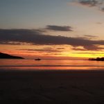
- The beautiful sunrise at Zoe Bay..
-

- ..as I enjoyed some quiet time doing my yoga this morning..
-

- ..David packing up the last of his gear before we head off for today’s hike..
-
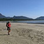
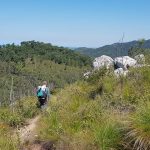
- ..heading on our way along Zoe Bay, at the start of our hike..
-
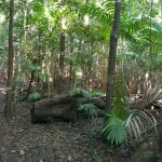
- ..we then walked through rainforest to the..
-
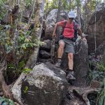
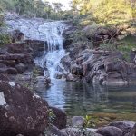
- ..base of Zoe Falls before climbing back up the rope..
-
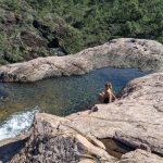
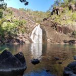
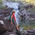
- ..to the magnificent pool at the top of Zoe Falls..
-
- ..where we both enjoyed a swim. David ventured further up the rocky track and did a couple of laps in a bigger pool..
-
- ..whilst I filtered some water from the creek for our hike today..
-
- ..as we set off across the rocky creek..
-

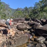
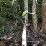
- ..we negotiate the tricky rocks across..
-
- ..and then start heading down. Always a little trickier balancing a 13kg pack and makes going a little slower..
-
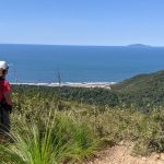
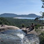
- Looking down to Sunken Reef Bay..
-
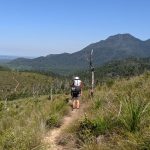
- ..as we walk through beautiful grass tree shrub land..
-
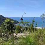
- A weather station just above Sunken Reef Bay..
-
- ..as we continue through the shrub land ..
-
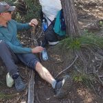
- ..David had a photographers mishap trying to get a good photo, lucky he wasn’t on a cliff edge.
-

- As we head down to Sunken Reef Bay, it was an unsure decision to head down there..
-

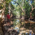
- ..but made a little interesting with this crocodile feeling..
-
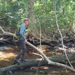
- ..as we negotiated the tree trunks across the waterfilled creek..
-

- ..we bothe made it across successfully today..
-
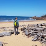
- Sunken Reef Bay was strewn with dead trees washed ashore and unforunately littered with plastics as well..
-

- ..we walked along the beach to find some shade..
-
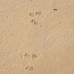
- ..and saw what we think were some marsupial footprints..
-
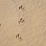
- ..as well as maybe some Beach stone curlew prints.
-
- A lovely spot under a palm tree for a quick lunch..
-
- ..then on our way back up again, passed some amazing trees..
-
- ..and back to the creek..
-
- ..where this time was a definite challenge of balance..
-
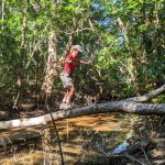
- ..which was okay until about this stage when the slope increased and got more difficult. We both made it without falling in. Phew!
-
- Then another big creek crossing..
-

- ..before looking out to George Point..e
-
- ..and finally descending to Mulligan Falls..
-
- ..our home for the night..
-
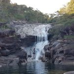
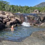
- ..another beautiful swim.
-
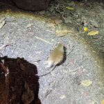
- Our little rodent friends at dinnertime.