Friday 16th July 2021
The day had finally arrived for our hike on Hinchinbrook Island . The weather is perfect, still and blue sky. As always I am a little agitated with a new adventure, the unknown always has me a little on edge. David has learnt to give me a wide berth and just leave me to my nerves. A few things are on my mind, but first and foremost is the presence of crocodiles. Scary scary scary. I was even nervous cooking dinner in the park at Cardwell last night even though we were away from the beach. Oh well. Onwards we go. Lucinda is a little fishing town and when we arrived at the wharf there would have been about 50 cars with boat trailers parked there. The car park was full.
We met John from Absolute North Charters at 7.45am for our departure at 8. There was a family of 6, father and daughter, 2 men in there 70s, a solo man 69 and us. Too many for the usual boat, so he had another guy help out. We spent the next 90 mins heading north from Dungeness near Lucinda up the channel between the island and the mainland. The water was smooth and clear and the view was amazing. The biggest peak on Hinchinbrook is Mr Bowen, I think it is about 1200m. After rounding the tip of the island we went through an inlet of mangroves and puttered along a narrow winding creek to the jetty. It was an amazing start to the day.
Ok, we hopped off the boat and put on our big pack, mine is 13.3kg and DBs is 13.5kg so I might have to give him the whole tent tomorrow. The initial part of the walk from the jetty was along a boardwalk through the mangroves. The view was amazing. Then out on to the beach where we walk about 200m south and then in to the bush which was a little rainforesty in some parts. Our packs are heavy and our fitness is low so it was a little bit hard on the inclines and the declines your momentum kept you going. About an hour into the hike we came to the fork to Mt Nina Peak 312m in elevation from a starting point of 80m. So a 232m climb. It was a tough slog even without our big packs. We stopped for a breather at the end of John’s track at a magic viewpoint but you know us, there was still rocks to climb so we found another track that took us to the peak. It was spectacular 360° views of where we had come from, the tributaries in the mangroves, the beach and the next destination. It sure had WOW factor. So much so we spent about an hour just enjoying the view and chatting to a couple of guys at the top. It was hard to drag ourselves back down. Heading down was also a little tricky as it was very steep. Then packs back on and off we go again. There was some downs, some tough ups and some more downs and ups, ups and downs, little dry creek crossings and a few with water. We had lunch at Nina Bay which was a lovely spot and made it to tonight’s camp about 3.30. It had been a tough day at the office, a 2 litre water day as it was quite hot and the terrain was tough. Everyone had a swim in the ocean but there were crocodile warnings which was enough deterrent for me and David was worried about stingers so we have it a miss today. A quick setup of our tent which is fantastic, a walk up the creek for water, some yoga on the beach, a wash in our tent, an early dinner before dark and off to bed at 6.30. Some story writing for you and now some quiet time reading. It is quite warm but we are away from the midges in the tent. We saw a few birds, two goannas and some amazing scenery. We have had a great first day. Bring on the next.
Day 1 – Track Notes
Ramsay Bay to Nina Bay (Grade: difficult)
Distance: 4 km Time: allow about 2.5 hrs hiking time
From the boardwalk, walk south to the headland at the southern end of Ramsay Bay. The trail head is marked with an orange marker, located to the right of a large granite rock. The trail follows a ridge before descending to the middle of Blacksand Beach. The trail continues along the beach beneath three broad-leaved tea-trees. It then passes through tall open forest of mainly Gympie messmate and on to the saddle below Nina Peak. Descending along a seasonal watercourse, the trail then enters a mangrove forest where stands of red-flowered black mangrove and spotted mangrove occur. It is best to cross the creek at low or half tide. The trail then follows the edge of the mangroves before emerging near the northern end of Nina Bay.
Nina Bay to Little Ramsay Bay (Grade: difficult)
Distance: 2.5 km Time: allow about 2 hrs hiking time
Camping area: Little Ramsay Bay southern side of lagoon
At the southern end of Nina Bay, the trail crosses a rocky section and heads towards the base of a small cliff. The trail climbs the cliff and follows the headland to Boulder Bay. At very high tides a detour through dense vegetation around the top of Nina headland may be necessary. Green turtles are often seen in the sea along this section. The trail then rock hops around Boulder Bay to the base of the headland at the southern end. At the southern end of Boulder Bay, orange markers indicate the trail, which travels south-east over the low ridge to the northern end of Little Ramsay Bay.
-
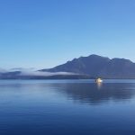
- View of Hinchinbrook Island from the jetty at Lucinda..
-
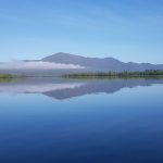
- ..as we travel north through the Hinchinbrook channel the water was clear and smooth….
-
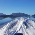
- ..looking out the back of the boat..
-
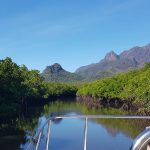
- ..as we round the top western side of the island and head into the mangrove tributary that takes us to..
-

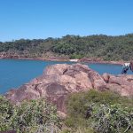
- ..the jetty that is at the track head of Ramsay Bay..
-

- ..as we disembark from Absolute North Charters boat John gives his last minute tips.
-
- The initial 100m or so is along a boardwalk over the mangroves..
-
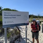
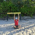
- This is the trail head sign for Hinchinbrook Island National PArk. Time for our adventure to begin.
-
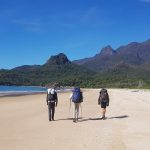
- As we walk south along the beach at Ramsay Bay, David chats with a couple of men doing the hike as well, Russell 72 has done this hike 15 times and his friend is 70 and it is his first time. David gets some additional tips from Russell.
-
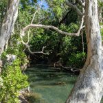
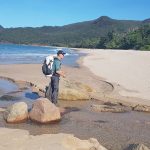
- Little creek at Blacksand Beach. The water was so clear.
-
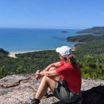
- A little rest at the first lookout point on the way up to Nina Peak, looking to where we are heading south..
-

- ..and David looking out over Ramsay Bay to the north…
-
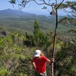
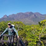
- ..then time to climb further up to the peak..
-

- View out to the North West of the island, viewing the mangrove tributaries..
-
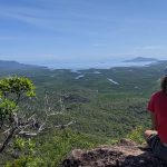
- ..where it felt very crocodiley.. This view was magnificent at 312m above sea level..
-
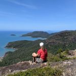
- ..Looking South what an amazing view..
-

- Heading back down was easier on your heart but a lot more challenging on your body as it was very steep and a little dry and slippery.
-
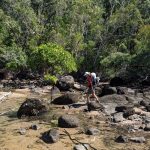
- Crossing a creek on the way to Nina Bay..
-

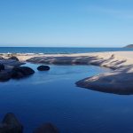
- We had lunch at Nina Bay Campsite and most people had a swim here as well, we then walked along the beach.. we head along the beach at Nina Bay..
-
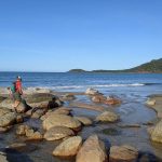
- ..looking back at Nina Peak as we started the rock hopping, this was an amazing workout for your quads..
-
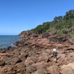
- ..it sure was difficult to navigate all the rocks but slowly and surely your skill and strength improved..
-

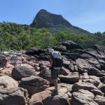
- ..and then there was the climbing with 14kg on your back. Definitely a challenge..
-
- ..as we look back to the peak from the headland..
-
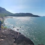
- ..and we head towards Boulder Bay..
-

- ..then finally arrive at Little Ramsay Bay..
-
- ..the mouth of Warrawilla Creek at Little Ramsay Bay..
-

- ..with Mt Bowen (1121m) in the distance..
-

- ..we setup our little hiking tent..
-

- ..and stored our backpacks in the racks to keep the white tailed rats out of our food..
-
- ..then headed back to Warrawilla Creek..
-
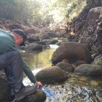
- ..to collect our water for dinner tonight and tomorrow’s hike..
-
- ..rock hopping back from the creek to camp..
-
- ..to have a rest and do a little yoga to ensure I can still continue on the walk tomorrow. Many of our fellow hikers had a swim here but we decided to listen to the WARNING signs about the crocs and had a sponge bath instead.